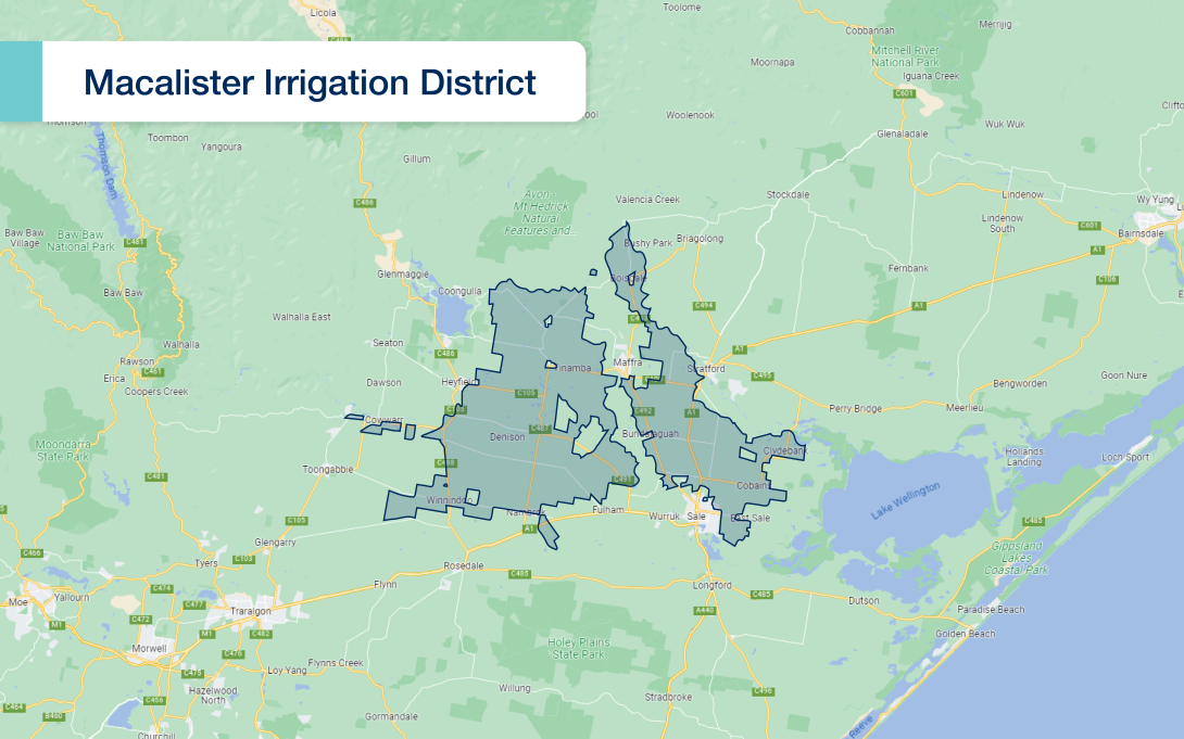
The Macalister Irrigation District is situated in Gippsland, Victoria, near the towns of Maffra, Stratford and Sale, approximately 200 kilometres east of Melbourne.
It is one of the largest and most productive irrigation districts in Victoria, Australia and the largest irrigation area south of the Great Dividing Range. This is due to its combination of fertile soils, reliable water supply, and infrastructure improvements to the irrigation network.
Soils across the area are classed as moderate to highly permeable, which means the area is perfect for pasture for animals to graze on and vegetable growth.
The district plays a crucial role in the state’s agricultural economy with major products including milk, dairy products, fodder crops, vegetables and beef.
The district covers approximately 53,000 hectares of irrigated farmland and is primarily supplied with water from Lake Glenmaggie, which serves as the main water storage facility for the region, and the Macalister River and associated irrigation pipelines and channels.

Order water over the phone or online using Waterline. Head to our water ordering page to find out more.
-
History
From the earliest days of white settlement after 1839, it was realised the region offered some of Australia’s most valuable grazing land. But the early settlers were at the mercy of rivers that dried up one year and flooded the next, and rainfall that came – or failed to come – in the most unpredictable way.
The first significant irrigation projects in Victoria began in the north west of the state around the turn of the century as a means of regulating the water supply. In the Macalister region, however, the first steps towards providing water for irrigation were taken in 1912 when the Water Commission became responsible for “closer settlement” – the name given to the process of encouraging people to relocate to and open up rural Victoria.
The Commission was asked by the Department of Agriculture to investigate providing temporary works to supply water to the sugar beet areas of Boisdale. Surveys were also made in that year to enable estimates to be prepared for a scheme to serve 2,400 hectares at Kilmany Park near Sale. A study of possible storage sites on one of the major rivers was initiated in 1914 following the disastrous drought of that year. The First World War intervened, however, and it was not until 1920 that a dam was begun on the Macalister River near the junction of Bradleys Creek, to be known as the Glenmaggie Dam. The Macalister was selected because it has a much larger average annual flow than the nearby Avon River.In the meantime, surveys were made to determine the feasibility of an irrigation scheme in the Maffra district to aid the sugar beet industry.
In 1919, Maffra landholders supported a proposal to supply water to irrigate an area of 9,000 hectares on the Avon flats, including Boisdale and the Newry and Maffra flats on the northern side of the Macalister River. This resulted in first priority being given to the construction in 1924 of the Main Northern Channel to supply the Boisdale and Newry River flats. A feature of that channel was its location in hill country on the northern fringe of the district. Very careful attention had to be given to the earthworks and the many water courses that had to be crossed with siphons (water carrying tunnels). By 1926, the Glenmaggie Dam was sufficiently advanced for water to be supplied to 3,600 hectares in Boisdale, Airly, Cobains and other estates near Sale. The Maffra and Sale Irrigation and Water Supply Districts, which then totalled 14,000 hectares, were constituted in 1927. At this time, proposals to supply Tinamba and the towns of Sale, Maffra and Heyfield were also being considered.
With the completion of the Glenmaggie Dam to crest level in 1929, the area under irrigation was progressively extended. To overcome problems of drainage, the Boisdale and Nuntin flats were drained to Nuntin Creek and the Sale and Bundalaguah areas to Lake Wellington . The Main Nuntin and Airly-Nuntin Drains were completed in 1930 and Myrtlebank Drain in 1931. By 1933 the area under irrigation was approximately 7,400 hectares, served by 310 kilometres of channels and 90 kilometres of drains.
The Maffra and Sale Districts were united to form the Maffra-Sale Irrigation District in 1935. After irrigation began, the area sown with sugar beet increased from 820 hectares in 1927 to 1,600 hectares in 1940. The amount of beet that was treated rose from around 20,000 tonnes per annum to over 40,000 tonnes in 1940. In the early 1940s however, butterfat prices began to increase and dairy farming became more profitable. The production of sugar beet declined and eventually ceased altogether in 1945, following which the processing factory was removed.
In 1942 a report was prepared for a Parliamentary Public Works committee on the utilisation of the waters of the Thomson River and their potential for irrigation of 24,000 hectares of land in the Nambrok and Denison areas, between the Thomson and Latrobe Rivers. These works were undertaken as part of the Central Gippsland Project, commenced in 1952 and completed in 1958. The Maffra-Sale Irrigation District was also extended in 1952 to include the Nuntin, Clydebank and West Boisdale areas, but it had become evident that the storage capacity of Lake Glenmaggie would be inadequate to meet both existing commitments and the projected requirements of the new Nambrok-Denison Scheme. Investigations were therefore made into the construction of crest gates on the Glenmaggie Dam and of a weir on the Macalister River at Maffra.
This weir, the Maffra Weir, was a vertical lift gated structure completed in 1954. It enabled flows from the Macalister River to be diverted into the Main Eastern Channel (constructed in 1958) to join with the Main Sale and Main Airly channels. These works removed the overloading on the Main Northern System by supplying the Airly, Sale and The Heart areas.
Lake Glenmaggie was enlarged from 130,800 megalitres to 190,410 megalitres by the addition of crest gates completed in 1957. This was followed by construction of the Cowwarr Weir on the Thomson River in 1959, to divert water to the Central Gippsland Irrigation Area along the Cowwarr Channel to supplement water from Lake Glenmaggie. The weir also maintains a supply of water in the old course of the Thomson River after a permanent breakaway course – Rainbow Creek – was formed during a severe flood in 1956.
In 1959, the Maffra-Sale and Central Gippsland Irrigation Districts were amalgamated to form the Macalister Irrigation District as it now exists, and the two former districts became irrigation areas within the district.
-
Modernisation
We began modernising the Macalister Irrigation District in 2013 and completed the work February 2024.
The Macalister Irrigation District modernisation project is a once-in-a generation initiative that delivers long-lasting and tangible benefits for our farmers, waterways and the environment.
The modernisation program was broken into phases to focus on work that delivered the greatest value in water savings and service improvements.
Phase 1A started in 2013 and finished in June 2017. It involved construction of the Willang Yarn balancing storage in Denison, the upgrade of regulators in the Nambrok-Denison supply system and upgrades to most Eastern system channels and all Heyfield channels. Achieving more than 4,000 megalitres of long-term average annual yield water savings.
Phase 1B was delivered in four stages. Worked started in 2017 and finished in 2020 and included a new offtake on the Main Southern Channel, installation of 38 km of new pipeline in the Southern Tinamba supply zone, and the upgrade of 28 km of existing channels at Riverslea. An estimated 9,600 megalitres in water savings was achieved.
Phase 2 program of works started in 2020 and included channel upgrades at Stratford and Boisdale. Pipeline was installed in the vicinity of Boisdale-Newry Road and Back Valencia Creek Road, and old manual wheels were replaced with new modernised outlets at four locations. Three regulators were also upgraded in the Main Northern Channel at Football Lane, Three Chain Road and Upper Maffra Road.
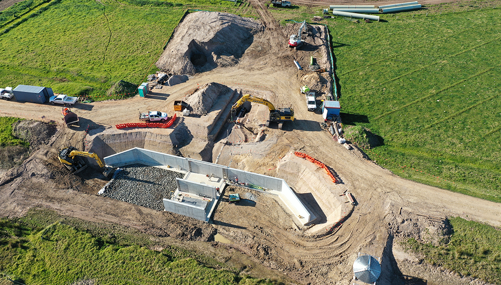
Phase 2 also included the delivery of the Newry pipeline, which was the final stage of works, with construction starting in November 2022 and finishing in February 2024 when we completed decommissioning legacy infrastructure.
The Newry pipeline replaced ageing channels with 17.25 kilometres of new pipeline, five kilometres of customer connection pipelines, in addition to outlet upgrades, reconnection works and decommissioning.
An estimated 7,200 megalitres in water savings has been delivered through Phase 2.
Our modernisation program has been vital in helping farmers be more productive and resilient to a hotter, drier climate future.
Thanks to modernisation, many farmers have implemented best-practice water use, invested in on-farm efficiencies and improved farm productivity.
Other program benefits include:
- efficiencies in the delivery of irrigation water and customer service improvements;
- water savings for the environment and agricultural production;
- improved safety by removing manual handling of old regulator infrastructure and;
- reduced outfall to the drain systems that helps reduce nutrients entering waterways and the Gippsland Lakes
Modernisation was jointly funded by Southern Rural Water, the Australian Government through the National Water Grid Fund and the Victorian Government
-
Operations
To distribute irrigation water from Lake Glenmaggie three main channels have been built – the Main Northern, the Main Southern and the Main Eastern. Construction began on the Main Northern Channel in the 1920s; the first delivery of water was made in 1925 to the Boisdale area, and within a few years the northern channel system had been extended to near Sale.
These years also saw the construction of the Main Southern Channel, which irrigates the area north of Tinamba. In 1939, it was extended to the Riverslea area and in 1952 was taken under the Thomson River via a 1,800 mm diameter pipe 1.3 km long, to the Nambrok-Denison area and to the east of Heyfield. Under a Soldier Settlement Scheme, 131 farms were laid out around Nambrok. Water was first taken there from Glenmaggie in 1952.
Eight years later, the Cowwarr Weir was constructed on the Thomson River six miles west of Heyfield, together with the Cowwarr Channel which augments irrigation supplies to the Nambrok Denison area when there are sufficient flows in the Thomson River. Today the Macalister Irrigation District has 660 kilometers of supply channels and 490 kilometers of drainage channels.
The Main Eastern Channel was built in 1958, following the construction of Maffra Weir on the Macalister River. This channel takes water from the weir to irrigators between Maffra and Sale.
Like Bacchus Marsh and Werribee Irrigation Districts, the MID is a gravity irrigation district and relies on upstream heads of water to move supply through the channels and pipes to the customer.
Water is ordered by customers through Southern Rural Water’s Waterline ordering system and delivered by our Water Services Officers through a complex series of checks, regulators and valves. This brings the water to the “farm gate”, where it is measured by a Dethridge wheel or Flume Gate on open channels or a standard flow meter on pipelines. From here it is directed by the customer to the on-farm irrigation systems.
Prices for water in the Macalister Irrigation District are determined by the Essential Services Commission following recommendation by the Southern Rural Water Board. This recommendation is made following consultation with the Macalister Customer Consultative Committee, which is made up of irrigators from within the district.
The irrigation season runs from 15 August to 15 May, although if supply and weather conditions are favourable, early starts and extensions beyond the scheduled close down are arranged.
-
Channel emptying for end of season
At the end of the irrigation season all channels in the Macalister Irrigation District are drained to allow for essential winter maintenance works, MID2030 project works and carp removal to be completed.
Customers that require water during the winter period from 15 May until 15 August will need to arrange alternate stock and domestic supply.
-
Private works
If you want to do works around (near, on or over) infrastructure controlled by Southern Rural Water – including open channels, pipelines and drains – you will need a licence to construct and use private works.
These structures can include:
- Occupational crossings
- Siphons
- New or replacement outlets
- Power or water lines
- Pivot crossings
- Or any other structures
How do I apply for a licence?
- Contact our Land Management Coordinator to discuss your plan. This will include an on-site meeting.
- Submit an application form: Request for the Approval of Private Works (no payment is needed up front)
- If approved, we will send you a written agreement with a request for fees for you to sign and send back with payment
- Once we have received this and approved the agreement, works can start
- During the project, our Land Management Coordinator will inspect regularly to check progress and that you are complying with specifications.
Security deposit
Part of the fee is a security deposit, which we will refund when the project is completed to the required standard and specifications.
Compliance
Please note that failure to comply with our processes and requirements is a breach of Section 148 of the Water Act 1989, and could result in prosecution.
-
Treating weeds in irrigation channels in the MID
Weeds block the flow of water in our irrigation channels. This prevents us from providing reliable service to our customers. Weeds need to be removed by machines or treated with herbicide.
At times, we treat weeds that float or grow under water with a herbicide. This is the best way for us to prevent weeds causing water delivery problems.
For more information see our fact sheet Treating submerged weeds in the irrigation channels MID.
-
Location
The largest irrigation area south of the Great Dividing Range, the Macalister Irrigation District (MID) is located in central Gippsland, south-east of Melbourne, and takes its name from the Macalister River, the main source of the district’s irrigation water.
The MID extends around the river for 53,000 ha from Lake Glenmaggie to near Sale. Approximately 33,500 ha is currently used for irrigation, and of this 90% is under pasture.
The main town in the MID and its business heart is Maffra, where Southern Rural Water has its head office.
Related pages
Click on these related pages to discover more about our Modernisation project, find related application forms and the current MID Allocations.