We have assessed our land holdings across southern Victoria to find suitable locations at Lake Merrimu, Lake Glenmaggie and Blue Rock Lake to generate carbon reforestation offsets to achieve our net-zero greenhouse gas emissions target.
Blue Rock Lake announcement
Community safety is at the heart of our proposal, and we engaged expert consultants to develop a carbon reforestation offset proposal for land we own at Blue Rock Lake. The robust assessments included bushfire risk, cultural heritage and ecological vegetation assessments.
The consultants identified several suitable sites. We reviewed these sites and further narrowed the reforestation proposal to 75 hectares of plantings at sites located well away from the Willow Grove township. These locations were presented to the community in October 2024.
We undertook extensive community consultation, including a drop-in session, face-to-face meetings, phone conversations and information available on our website and social media.
After listening to the community, we heard that the major concerns regarding bushfire risk had been addressed by restricting planting to 75 hectares (from the available 200 hectares that Southern Rural Water owns at Blue Rock Lake) and ensuring these locations are well away from the Willow Grove Township.
A small number of people expressed they’d like additional bushfire buffers around the Hunts Road area. We committed to listening to all feedback provided by the community and in response, we’ve removed a further four hectares of plantings at the north-west corner of Blue Rock Lake around Hunts Road.
We will now progress with 71 hectares of plantings.
We heard that weed and pest control is important to the community – and we confirm that this will be actively managed for the lifetime of the plantings. Weed and pest management is a requirement to be able to claim the carbon credits associated with these plantings and will be the subject of regular audits to ensure it’s being undertaken effectively.
More Information
-
What is Southern Rural Water’s decision on the carbon reforestation offsets planting proposal at Blue Rock Lake?
After listening to the community, we heard that the major concerns of the community regarding bushfire risk had been addressed by restricting planting to 75 hectares being planted (from the available 200 hectares that Southern Rural Water owns at Blue Rock Lake) and ensuring that these locations are well away from the Willow Grove Township.
A small number of people expressed that they’d like additional bushfire buffers around the Hunts Road area. Southern Rural Water committed to listening to all feedback provided by the community.
After careful consideration, and consulting with our technical team, we are progressing with planting 71 hectares of land, removing four hectares of land around the Hunts Road area – which provides additional bushfire buffers in this area.
-
What has informed this decision?
Along with technical reviews and assessments, which covered bushfire risk, cultural heritage, land suitability and visual amenity, Southern Rural Water undertook extensive community consultation, including a drop-in session, face-to-face meetings, phone conversations and information available on Southern Rural Water’s website and social media.
The decision was informed by feedback from the community, and in engagement undertaken with licence holders (people who currently have access to Southern Rural Water land), the Willow Grove Country Fire Authority and other key stakeholders.
-
How was bushfire risk assessed?
A technical expert produced a bushfire risk analysis that made recommendations on the suitability of sites for planting and mitigations to be implemented for the planting proposal.
This also included identification of the bushfire landscape risk and likely radiant heat impacts. The analysis included site visits, assessment of available information including municipal fire management plans, bushfire planning overlays, and legislation.
The analysis considered topography and its influences on bushfire behaviour, including under conditions such as prevailing winds. The full report can be read here.
Further, the planting proposal does not change the Bushfire Management Overlay, which is a Victorian Government planning instrument that applies to land that may be at risk of bushfire to include specific bushfire protective measures. Our proposal contains bushfire buffer zones, which reduces the potential for a Bushfire Management Overlay to be applied in the future.
-
Are there any changes to the proposal?
Yes. A small number of people requested additional bushfire buffers around the Hunts Road area. Southern Rural Water has included additional buffer zones in this area, reducing the overall planting area from 75 hectares to 71 hectares.
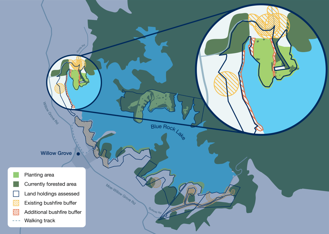
Original proposal: Above is the original proposal that Southern Rural Water provided the community during its consultation in October and November 2024.
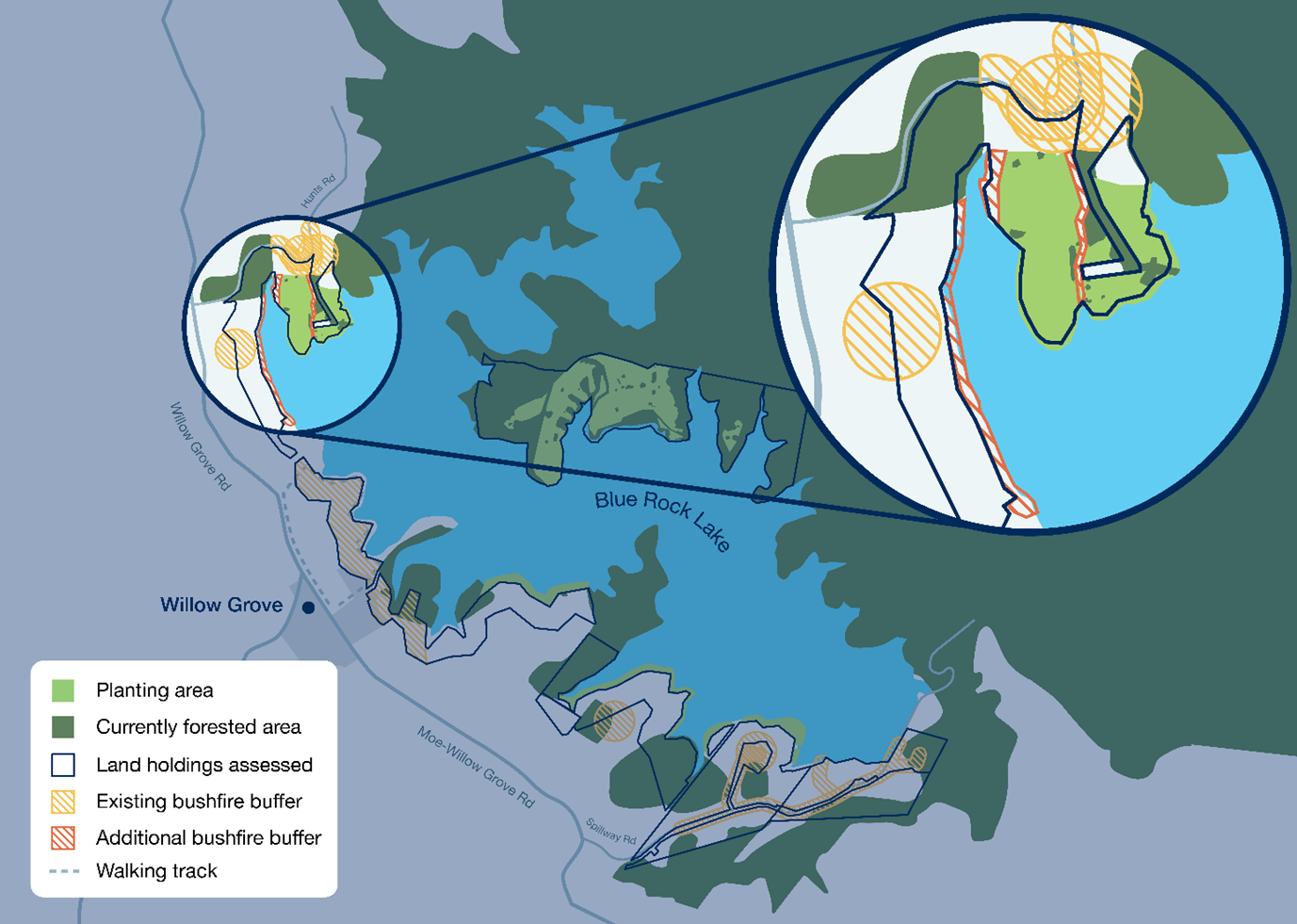
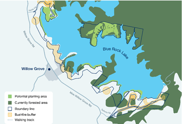
Amended proposal: A small number of residents requested additional bushfire buffers near Hunts Road. Southern Rural Water has increased bushfire buffers in this area, removing four hectares of plantings at the north-west corner of the lake around Hunts Road. This will reduce planting from 75 hectares to 71 hectares.
The additional buffers south of Hunts Road (as seen on the map) mean the northernmost planting area does not connect the existing forested area around the bend of Hunts Road.
Planting sites now include 44 hectares at the eastern side of the lake, eight (previously 12) hectares along the bank of the lake and 19 hectares at the northern end of Blue Rock Lake.
-
How will the changes impact the amount of carbon credits that can be generated?
The changes are estimated to be a reduction of 1,900 Australian Carbon Credit Units across the lifetime of the project. SRW is pursuing other planting opportunities near Lake Glenmaggie and Lake Merrimu to meet its obligations to achieve net-zero greenhouse gas emissions.
-
What are the next steps?
A tender will be issued in mid-2025 for the supply and planting of seedlings and maintenance of the planting sites.
Site preparations will begin early 2026, and planting at Blue Rock Lake will commence during winter 2026. It’s expected plantings at the site will take approximately three months.
-
What weed and pest management controls will be in place?
We heard that weed and pest control is important to the community – and we confirm that weeds and pests will be actively managed for the lifetime of the plantings. Weed and pest management is a requirement to be able to claim the carbon credits associated with these plantings and will be the subject of regular audits to ensure this is being undertaken effectively.
Southern Rural Water will maintain and preserve the carbon stored in the trees until 2050 to align with Australian Government requirements.
-
Why is Southern Rural Water considering carbon offsets?
Carbon reforestation offsets involve planting trees to capture carbon dioxide from the atmosphere and contribute to reducing the effects of climate change. To reach our net zero target, Southern Rural Water has committed to carbon reforestation offsets, which helps reduces emissions.
The carbon reforestation offsets project could remove up to 34,300 tonnes of carbon dioxide from the atmosphere over 25 years, which will generate carbon credits to support Southern Rural Water’s emissions reduction plan.
-
What has Southern Rural Water done to reduce its carbon emissions?
Southern Rural Water is already reducing greenhouse gas emissions through the transition of vehicle fleet towards zero emissions by 2030, partnering with Wannon Water to exchange Australian Carbon Credit Units, installing solar panels and purchasing green energy.
-
What land has Southern Rural Water assessed for carbon reforestation offsets?
Southern Rural Water has assessed land holdings across southern Victoria, including sites at Blue Rock Lake, Lake Glenmaggie and Lake Merrimu to see if there are suitable locations to undertake carbon reforestation offsets that could help us achieve our net-zero greenhouse gas emissions target. In total, Southern Rural Water assessed 376 hectares of its land holdings across southern Victoria, including approximately 200 hectares at Blue Rock Lake.
-
What are the project benefits?
The Carbon Reforestation Offsets Project will remove up to 34,300 tonnes of carbon dioxide from the atmosphere over 25 years, which will assist Southern Rural Water to reduce emissions.
Our project sites are in the marginal lands of drinking water storages. Reforesting these sites will improve water quality that will have flow on benefits for urban water authorities and their customers.
By planting species that are native to the local area, the project will create habitat and corridors for a wide range of flora and fauna and connect areas of existing vegetation across the landscape.
Reforestation will reduce nitrogen and phosphorous runoff into our water storages and prevent erosion, with subsequent benefits for water quality.
Reforestation will also increase organic matter and infiltration rates within the topsoil, improving overall soil health.
-
What will happen to carbon credits produced?
Our carbon reforestation offsets have the potential to earn one Australian Carbon Credit Unit (ACCU) for each tonne of carbon dioxide equivalent (tCO2-e) stored in the project trees as they grow.
The Clean Energy Regulator will use geo-spatial tools to confirm that the planting activity has happened, verify that abatement is being achieved, and monitor for disturbances. Our offsets will be assessed at regular intervals to confirm they remain compliant.
We will support these assurance mechanisms, and it will enable the regulator to calculate how much carbon has been captured and stored. After verification, we’ll earn one ACCU for each tCO2-e stored by the trees.
With Southern Rural Water, the carbon credits earned will be used to offset our Scope 1 vehicle emissions while we transition all our fleet to zero emissions by 2030.
-
What plants are you using?
We have conducted field research and soil testing at all our offsets sites which will be used to inform the species we plant that are compliant with Australian Carbon Credit Unit Scheme, reduce bushfire risk and achieve our carbon offset goals.
We will be planting species that align with the local Victorian Ecological Vegetation Class (EVC) benchmark with a higher tolerance for drier and more variable climatic conditions to ensure greater success establishing and maintaining resilient reforested areas at our sites.
The final summary report for the Carbon Reforestation Offsets Project can be viewed here.
This report considered the suitability of offsets sites at Blue Rock Lake, Lake Glenmaggie and Lake Merrimu, and any bushfire risks, cultural heritage and other matters.
-
What is the proposed life span for the carbon reforestation offsets?
The project will have a 25-year permanence period under the Australian Carbon Credit Unit Scheme.
-
Will plantings change the landscape?
From the Willow Grove township, there will be minimal changes to the visual landscape.
From areas north and south of the township where the proposed planting areas are along the lake’s edges, the outlook would be similar to the existing planting along the walking track that follows the lake shore in front of Willow Grove.
-
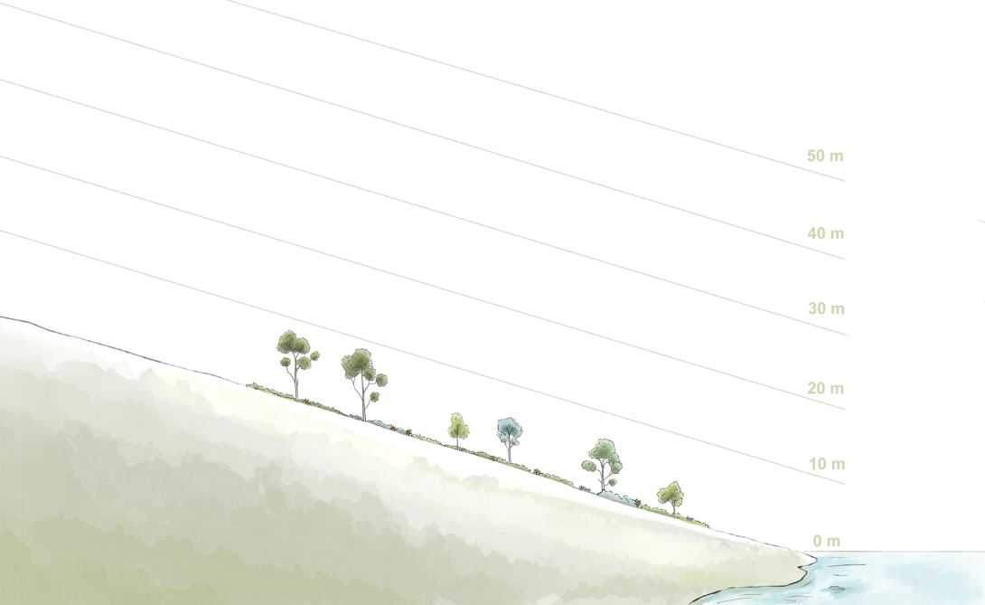
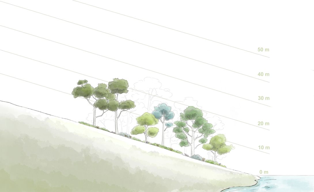
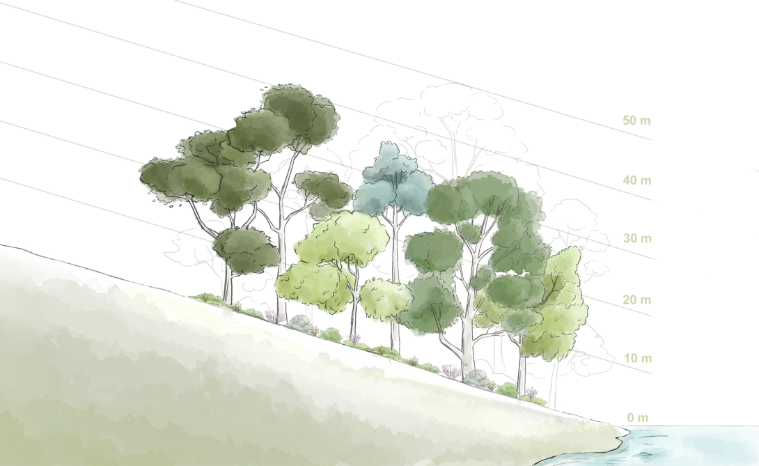
What might the sites look like?
Below is an artists’ impression of what the sites might look like in 5, 10 and 30 years’ time. They are included here as a guide.
After 5 years
After 10 years
After 30 years
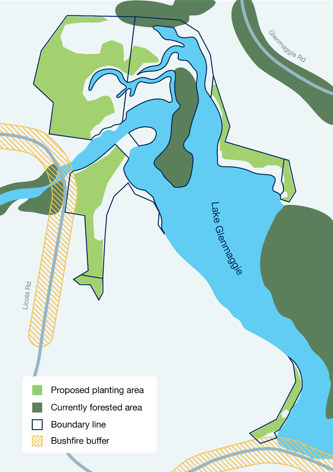
Plantings at Lake Glenmaggie
Southern Rural Water has considered forestry assessments at a range of sites and determined it will prioritise planting at Lake Glenmaggie. It’s proposed to plant out 13 hectares of new forest at the lake.
Following a tender process, a suitably qualified service provider has been appointed to procure, prepare and plant trees at Lake Glenmaggie, with work expected to begin in July 2025.
What is involved in planting?
Carbon reforestation offsets involve planting trees to capture carbon dioxide from the atmosphere and contribute to reducing the effects of climate change.
Planting involves a mixture of native and local tree, shrub and understorey species to establish new and permanent forest cover. These projects earn one Australian Carbon Credit Unit (ACCU) for each tonne of carbon dioxide equivalent (tCO2-e) sequestered by trees as they grow.
We are already reducing our greenhouse gas emissions through the installation of solar panels, transitioning towards electric vehicles and the purchase of green energy. Planting trees to generate carbon offsets will help us to mitigate our climate change impacts, whilst reducing emissions at their source.
Benefits of planting for carbon offsets
There are multiple co-benefits associated with planting trees to generate carbon offsets. By planting species that are native to the local area, it will create habitat and corridors for a wide range of flora and fauna and connect areas of existing vegetation across the landscape.
Reforestation of our land will also remove invasive flora and fauna species and improve the resilience of local ecosystems.
Reforestation will reduce nitrogen and phosphorous runoff into our water storages and prevent sedimentation, with subsequent benefits for water quality. By vegetating the area around our storages, the forested area will help to reduce erosion along the banks, improving water quality and overall integrity of the storage.
Reforestation will also increase organic matter and infiltration rates within the topsoil, improving overall soil health.